Radiation


Being a data nerd, I have been collecting some data while flying around. I was curious to see the effect of both altitude and latitude on background radiation level. This is well known stuff, but it is always reassuring to do your own measurements and see the effect of physics at work.
The first chart is from flying down to Pebble Beach today, cruising at ~41,800feet. It is a set of collections of altitude and measured radiation level in uSv/hr. Background radiation level in Portland is right around 0.10uSv/hr, a tad under the national average.
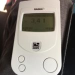
You can see the profile of radiation level correlates well to altitude. Peak measurement on this trip was 3.41uSv/hr, or a bit over 34 times regular background radiation. Indeed the atmosphere makes a big difference!
It is hard to detect, but if you average the data there is a slight downward trend at the same altitude as we fly south.
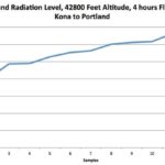
The second graph is from a flight earlier this year flying home from Hawaii at 42,500 feet. All of these datapoints are from the same altitude, the slope of the curve is entirely caused by the change in latitude. As we go north, we move into the thinner parts of the Van Allen belts and as a result the radiation at altitude is higher.
Science, it works!